Heading into Mesa, AZ from Calsbad - 550 miles


On Interstate 10, we passed through Tucson and loved the college radio station we found on the radio! Awesome indie music. Along the drive, we played our collection of cds from time to time, but really enjoyed just letting our minds wander looking at the scenery and sharing our thoughts on the day's news or matters of the hearts of animated travelers. Right outside of Tucson, we watched two air force pilots practice maneuvers dipping in and out of view masqueraded at times by the brightness of the sky or the shadow from a mountain.
We pulled into Mesa to a RV resort that to that point was by far the largest RV park we stayed at, even overshadowing the KOA in New Orleans by a few hundreds spaces. When we arrived, there were square dancing lessons in one of the rooms and Marilyn, being our trophy senior, wasn't willing to sign up for lessons the next day, so we scratched that idea off the list. We did however all take on board the hot tub and ended up enjoying that hot tub for the next two nights! A hot tub in gorgeous weather is just delightful.
When we woke up the next morning, we ended up having to get the RV cleaned to turn it in and replace it with a new RV for the second leg of our trip. Although it seems strange to have to do that, let me explain. We got a great deal since Cruise America needed the RV that we rented on the East Coast to be brought to Mesa, AZ, so by helping them out, since we were going one way, we received a good deal and needed to use two different RVs to get to our destination in CA. Our stop through Mesa was going to be hours, but it didn't end up that way, thankfully. What were the great incentives to stay? The weather was gorgeous, we loved the hot tub, and there is a great cacti forest called Tonto National Forest that we avidly craved to hike. We also enjoyed a great Mexican lunch at Ranch de Tia Rosa where the secret recipes of grandmother Rosa are being shared by a grandson who opened a restaurant in her honor. Only one other chef in the kitchen knows the recipes by heart! Rosa sure knew how to cook!
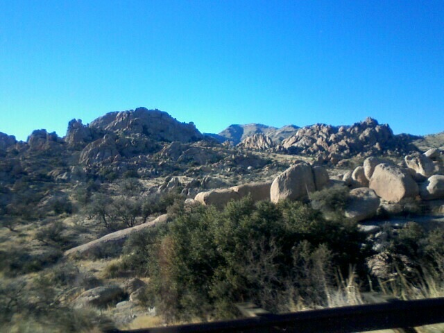
While Marilyn and I didn't carry the camera to the hot tub area, we did carry it all over Tonto National Forest. Justin went golfing at a great golf course in Mesa and Marilyn and I hiked in Tonto National Forest. We decided to take the Pass Mountain Loop Trail clockwise. Being committed to the trail and its completion, we didn't notice the warning on the map about the steep descent 3/4 of the way around the loop until we were there. Although we did notice that some mountain bikers on other sections of the hike weren't having the types of days they thought they might have full of joyful adventure - more like split skin and medical tinctures!


Pass Mountain trail is located in the Usery Mountain Park and runs through Tonto National Forest. It is a 7 mile loop. Marilyn and I started our hike at the horse staging/picnic area at the east end of the park.


Some of the highlights from the hike included running into a wonderful mother and daughter team who we ran into early on in the hike and then again at the 3.9 mile mark at the Pass, where they took our picture together. It's a beautiful spot where you can see the back of the Pass Mountains and the entire view over the valley to surrounding cliffs is spectacular. I still have to get that picture off of Marilyn's camera! Just reminded me. We also ran into a wonderful woman who is 77 Lolly who comes to Mesa every year from Oregon to enjoy the weather. She said she also bikes 20 miles a few times a week, and loves this particular trail. She just hasn't found anyone willing to take the hike with her and Marilyn told her she wished she lived close to her in Santa Rosa.
Marilyn and I also had a great deal of adrenaline kind of fun learning how to work as a team when we reached a spot on the trail that gave us two options and we figured out, through the process of elimination, that we had reached the steep descent on the trail that the map warned about. Some people apparently turn back at this point. Not us, but first we wanted to explore our options. Our first choice took us to the left, and as we walked to its end we realized it was a dead-end to a closed off wind tunnel. The entire time Marilyn and I giggled about how we hadn't picked the steeper choice because from where we both stood it looked like a goat trail. So, we took what looked like a goat trail and Marilyn is a super trooper. We really had a great time and challenged ourselves and felt that sweaty palm feeling you get when you're dealing with heights. Most of all, both of us enjoyed spending some time together and seeing this gorgeous forest of cacti!
No comments:
Post a Comment